https://cuilcaghlakelands.org/about-us/what-is-a-geopark/geology/
Geology is an Earth science, however, here at Cuilcagh Lakelands Geopark, Geology is so much more. It is the greatest historian, the most captivating storyteller and the guardian of a time long forgotten. With each different rock-type that is discovered and explored within the Geopark, a new and exciting story is revealed about our history, our environment and our world.
Let’s go right back to when our story first began.
To begin exploring the oldest rocks in the Geopark, we’ll have to go back over 895 million years ago! These ancient treasures can be seen on the northern shores of Lower Lough Erne in Tullychurry Forest. Unique to all other rocks in the Geopark, these rocks are linked to the rugged and often desolate Sperrin Mountains and Donegal Highlands. This type of rock is known as metamorphic, and it is from these rocks that the original raw materials for Belleek Pottery were first sourced.
Approximately 500 million years ago, a vast ocean lay between two supercontinents that were home to each half of the modern island of Ireland. This ocean began to diminish, allowing the landmasses to slowly (but surely!) move closer together. Remains of this ocean are preserved as mudstones beneath Lough Oughter in County Cavan and in some of the surrounding landscape on the southern shore of the lake. After around 50 million years, these two supercontinents eventually collided, and the results were earth-changing. The enormous pressure of these huge land masses pushed the land upwards, creating what we now know as the Donegal Highlands and Sperrin Mountains and bringing together, both halves of the island of Ireland.
By this stage, the two halves of Ireland were joined together, however they were still connected to one huge continent! And believe it or not, the land that we now call the island of Ireland was located approximately ten degrees south of the equator (In roughly the same place that the Sahara Desert is now! Now that is hot!). This hot, barren, extreme desert landscape was often met with flash floods forming many rivers and small lakes. From these extreme processes, red sandstones were created that can be found in and around Castle Archdale Forest. Most of these rocks are hidden, but if you look very closely at some of the boulders on the lake shore, you may just see a glimpse of Ireland’s desert past.
Ireland’s time in the heat didn’t end with it’s desert experience. In fact, 330 million years ago, Ireland lay close to the south of the equator. Located on the edge of a supercontinent, the sea levels were higher, meaning that the land we now call Ireland was submerged by a tropical sea. This led to the creation of the Geopark’s most dominant rock, Limestone. This occurred through lime-mud on the bottom of this prehistoric sea floor combining with the remains of dead sea creatures that would have saturated these waters. Limestone forms the bedrock of many of the middle slopes of Cuilcagh Mountain and makes up many of the caves in the Geopark. The limestone is often full of fossils, allowing us an insight into the many creatures that dwelled those shallow seas, millions of years before us.
The shallow tropical seas that Ireland was once consumed by, began to disappear due to a fall in sea level around 320 million years ago. What came next? A huge river delta. This massive system began in the area we now know as South Donegal, bringing with it plenty of sand and silt. During this time, coal began to form thick and fast throughout Europe due to the tropical conditions and large amounts of land plants. The result of this active time in geological history resulted in sandstone, which makes up the summit of hills such as Cuilcagh Mountain, Belmore Mountain and Slieve Rushen.
Let’s move on to some younger rocks. By younger, we mean, rocks from around 65 million years ago. By this time, the land we know as Ireland had moved much further North to somewhere similar to present day Mediterranean. The active earth movements had a considerable impact on the Irish landscape, to include explosive volcanic eruptions which led to the formation of the Giant’s Causeway in County Antrim. Of course, the Geopark also felt the impact of this turbulent time in geological history. The stresses on the landscape pushed molten rock up towards the cracks of the Earth’s surface, however they did not make it through the top! The molten rock cooled and hardened, forming sheets of solid rock within other rock types. These exciting results of nature have been named Dykes and some of these can be viewed at Lough Navar Forest as well as in Cuilcagh Mountain Park.
The last glaciation or as we like to call it, “The Big Freeze” had the biggest impact on the current landscapes of the Geopark. The monumental, 600 metre thick, ice sheets that wreaked havoc on much of Europe caused huge change across the area.These sheets melted 13,000 years ago, but prior to this, they moved, shaped and moulded the landscape, forming breath-taking valleys, beautiful drumlins, and ribbed moraines. You’ll find these spectacular treasures at Lough MacNean and within the Lake Oughter lake system. “The Big Freeze” also left some glacial debris such as sand and gravel deposits outside of Ballyconnell and the hundreds of huge boulders across the countryside known as glacial erratics.
Ireland’s time under ice was officially over, and grasses, willow birch and other heath plants began to blossom and grow in the icy blanket’s place. Giant Irish deer, wolves and brown bears occupied the newly formed landscape and as the ice melted, vast amounts of water gushed across the land, forming the many lakes of the Geopark, including Lower Lough Erne, Lough Melvin and Lough MacNean. With warmer temperatures and lower precipitation, eventually most of Ireland was covered in dense forest, which led to the extinction of larger mammals, such as the Giant Irish Deer. As human settlers began to inhabit the area, deforestation, burning and grazing served as perfect encouragement for peat growth, creating much of the internationally significant blanket bog that is part of the Geopark.
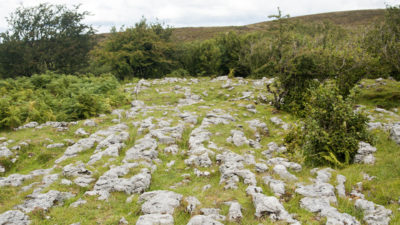
The caves that populate the Geopark are some of the most fascinating and beautiful features of the landscape. Shaped by water that has flowed for over 330 million years, they hold history and stories that are much too ancient for us to ever fully understand. No one is sure when the caves were formed, but we know that they occur when limestone is slowly dissolved by weakly acidic water, such as rain water. There are numerous caves within the Geopark, including the most famous, Marble Arch Caves. In many areas of the Geopark, a similar reaction has occurred on surface limestone, creating a water-worn, rugged, rocky appearance. This has often been referred to as limestone pavement . This can be best spotted at Corratirrim along the Cavan Way.
This is a cooperation project between Fermanagh and Omagh District Council and Cavan County Council.
This element of the project is part funded under Priority 6 (LEADER) of the Northern Ireland Rural Development Programme 2014-2020 by the Department of Agriculture, Environment and Rural Affairs and the European Union. We would like to acknowledge the assistance of County Cavan Local Community Development Committee (LCDC), Cavan County Council, Breffni Integrated CLG, Department of Rural and Community Development, the EU and EAFRD in part-funding this project. Funded by the Irish Government Under the Leader Programme 2014-2020.