https://cuilcaghlakelands.org/itinerary/fermanagh-uplands/
The Fermanagh Uplands route takes in some of the most breathtaking viewpoints in Ireland. Travelling past hidden caves and secret waterfalls, this journey helps to uncover some of finest hidden gems that the Geopark has to offer.
Distance: 75km/47miles
Time: Approx 4 hours by car
The Cottage lawn is an amenity area in the village of Belcoo on the shores of Lough MacNean and alongside the Belcoo River. It is home to some exceptionally mature trees and offers fine views across to the Hanging Rock (see the Marlbank route) and Cuilcagh Mountain.
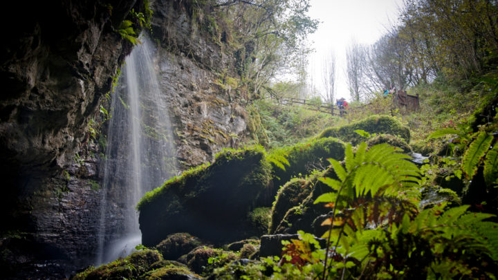
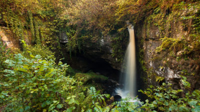
Belmore Forest is one of many forested areas owned by Forest Service NI within the Geopark. Many of the forests contain walking routes such as the one here at Belmore Forest that takes you past many fascinating geological and historical sites. Coolarkan Quarry and Polnagollum Cave are both close to the start of the walk at Belmore Forest and are formed from limestone that was deposited around 330 million years ago. At that time the whole of the island of Ireland would have been covered by a shallow, tropical sea similar to that found in the Great Barrier Reef today.
The beautiful RIC (Royal Irish Constabulary) Station at Boho is constructed from local sandstone and is now a private residence not open to the public. Made infamous for holding the notorious informant Dominick Noone, it was from here that Noone escaped in 1826, only to be captured by his Irish rebel contemporaries before being tortured and thrown to his death down a nearby cave. The cave in question is now known as Noon’s Hole, previously known as sumera, an Irish word for a bottomless pit due to its unusually deep,81 metre entrance shaft.
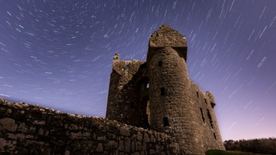
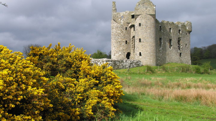
The Plantation of Ulster in the early 17th Century was an attempt by the English monarchy to take control of the troublesome province of Ulster. After attempts by Queen Elizabeth I in the 16th century, it wasn’t until the Flight of the Earls in 1607 that King James began to confiscate lands and grant it to those who would settle in Ulster and support the royal claim. Many of these settlers were English and Scottish and finding themselves amongst a hostile native population, they built defensive dwellings, called Plantation Castles. The largest and best preserved of the Plantation Castles is at Monea, and was built by 1618 for Malcolm Hamilton. The castle follows the traditional castle and bawn style with the bawn being a walled enclosure.
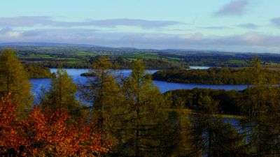
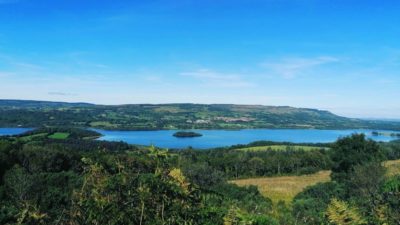
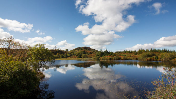
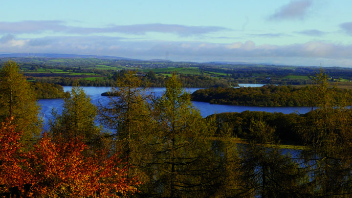
The outlook from the Carrickreagh Viewpoint is spectacular with views over the Bluestack Mountains of County Donegal to the North and Sligo Bay and the Atlantic Ocean to the West as well as looking down on Lower Lough Erne and its islands. The most striking feature of the landscape is undoubtedly Lower Lough Erne. The formation of the lake can be traced back to the last Ice Age when huge ice sheets scraped out huge u-shaped valleys such as the one now occupied by Lower Lough Erne.
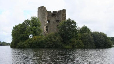
The small island of Inishmacsaint can be reached via a pontoon, a short walk from the car park. Inishmacsaint is one of several important ecclesiastical sites located along the natural waterways of the Geopark. The founder, Saint Ninnid, lived in the 6th century, and was a contemporary of Saint Molaise of Devenish and Saint Mogue of Drumlane (see the Cavan Drumlins route). This early monastic site contains a comprehensive record of different church styles and a distinctive High Cross, thought to date from the 10th or 12th centuries.
The village of Derrygonnelly dates back to the Plantation of Ulster and was founded by General Archdale during that time. The village has a long history of Irish traditional music and each year in October there is a traditional music festival when musicians from all over Ireland and further afield come to enjoy the festivities. The Derrygonnelly Field Studies Centre offers a range of environmental courses.
Big Dog Forest is one of many forested areas owned by Forest Service NI within the Geopark. The forest is steeped in history and legend and it is widely believed that the forest is named after the larger of two small hills that dominate the skyline, known as Big Dog and Little Dog. They are named after Bran and Skeola (Sceolan), two favourite Irish wolfhounds belonging to the legendary giant Finn MacCool; legend has it they were cast into stone by a witch whom they were out chasing. There is a walking route in place within the forest, the highlight of which is the 360 degree view from the top of Little Dog where you can catch glimpses of the many hidden lakes that exist among the conifer plantations.
Located on the border between County Fermanagh (Northern Ireland) and County Leitrim (Republic of Ireland), the small town of Garrison gets its name from a barracks erected by William III who halted here after the Battle of Aughrim in the 17th century.
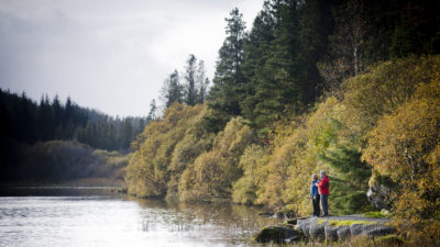
Lough Melvin is an exceptionally important lake due to its important fish species, some of which are found nowhere else in the world. One such species is the Lough Melvin gillaroo (or Salmo stomachius) that gets its name from the Irish for ‘red fellow’ due to its distinctive red colouring. The gillaroo feeds primarily on snails, and other bottom-living creatures and although similar fish species are found in other Irish lakes, this one is unique to Lough Melvin. The Lough Melvin Holiday Centre has a busy cafe and the walks in the nearby loughshore amenity area provide excellent views of the Leitrum Hills.
Located just outside the village of Belcoo, Saint Patrick’s Holywell is one of many springs in the region. The predominant limestone bedrock in the area dissolves in weakly acidic water allowing channels to be eroded within the rock and on top of it. Much of the water in this region flows through limestone rocks and where it reappears at the surface it is called a spring. Many of these springs have been termed ‘holy wells’ and this one is said to have been blessed by Saint Patrick himself. Saint Patrick’s Holywell is unusual as it flows in two directions and is also said to be the coldest in Ireland. Many such springs are reputed to have healing powers and as a result Saint Patrick’s Holywell is a place of pilgrimage for many local people who perform the Stations of the Cross during the Festival of Lughnasa at the end of July.
Coolarkan, Fermanagh
Belmore Forest offers something for everyone: breath-taking views, local wildlif...
Enniskillen, Fermanagh
A stunning site, giving visitors views of one of the largest and best preserved ...
Take your time to explore the fascinating, picturesque and unique landscapes tha...
The Cuilcagh Mountain route takes you all the way round the majestic Cuilcagh Mo...
This is a cooperation project between Fermanagh and Omagh District Council and Cavan County Council.
This element of the project is part funded under Priority 6 (LEADER) of the Northern Ireland Rural Development Programme 2014-2020 by the Department of Agriculture, Environment and Rural Affairs and the European Union. We would like to acknowledge the assistance of County Cavan Local Community Development Committee (LCDC), Cavan County Council, Breffni Integrated CLG, Department of Rural and Community Development, the EU and EAFRD in part-funding this project. Funded by the Irish Government Under the Leader Programme 2014-2020.